Pittsburgh and the Allegeny River
Digital Image
Collection number: Map 10-P
Dates
- Digitized: c 1900
Creator
Rights Statement Note
Educational
Physical Description Note
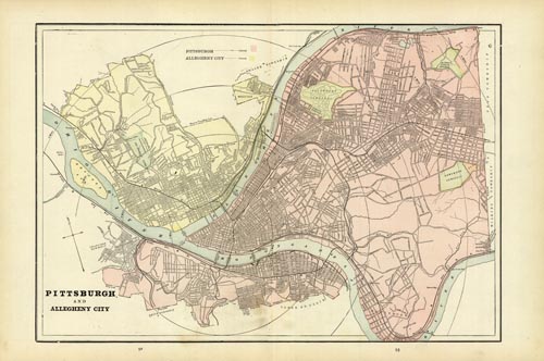
1 map : color ; 18 1/2" x 13" Publisher: George F. Cram ; Chicago Framed Publshed in several atlases between 1893-1905 by the George F. Cram Company, a highly regarded publisher of maps. Shows city limits, streets, railroads, cemetaries and parks. Bullseye circle centered on downtown Pittsburgh,
Publisher Note
Publisher: Valdosta State University Archives and Special Collections
Contributor Note
Contributor: Voctoria Pennington
Repository Details
Part of the Valdosta State University Archives and Special Collections Repository
Contact:
Valdosta State University Archives, Odum Library
1500 N. Patterson St.
Valdosta GA 30601 United States
7063728116
229-259-5055 (Fax)
archives@valdosta.edu
Valdosta State University Archives, Odum Library
1500 N. Patterson St.
Valdosta GA 30601 United States
7063728116
229-259-5055 (Fax)
archives@valdosta.edu